Update September 21, 2020
Construction is to begin on this project this week.

Update June 12, 2020
A public meeting was help by zoom on June 4, 2020 to share the plans and hear public comment. There was a great turnout with a lot of feedback. If you missed the meeting, you can replay it here:
And you can submit public comment by completing the survey before June 19.
April 30, 2020
The ongoing issue of flooding and stagnant water collection at the corner of Goodland Ave and Cohasset St. near the Charles Leroy Lowman Elementary School is planned to be addressed before the next rainy season.
When it rains, water to the northeast drains to this location and doesn’t quite make it to the drainage route which would take it along the side of the school, out to Saticoy. Instead it collects, stagnates, attracts mosquitoes and more. And then children walk past it to school.
Council District 2 recommended this issue to the Department of Sanitation Stormwater and Watershed Management Group as an area ripe for their projects which are aimed at capturing more stormwater, which as you may recall, mostly all gets routed out to sea. The Stormwater and Watershed Management Group has funding to complete projects that will capture more stormwater and route it to underground aquifers. These projects would likely also provide the benefit of reducing flooding.
The project is currently in the predesign phase with the plan of capturing public comment in the coming months and beginning construction in July & August, so that it would be in place before the next rainy season.
The initial plan calls for adding a drain approximately where the green box is on the below image, which is not to scale (and the drain would not be green). The black lines represent a grate meant to capture debris and trash. The debris would be cleared as part of regular grate clearance in the neighborhood. Sanitation will provide us with an approximate schedule.
After collecting water at through this grate, it then drains to a primary dry well, which when it is full enough overflows to a secondary dry well. The dry wells would be underground and approximately 6′ in diameter with structural support on the sides and an open bottom with the goal of allowing the water to be absorbed into the underground water table.
The map below shows how water within the boundary of the purple lines flows to that location and where the wells could go.
Project leaders will be holding a virtual public meeting June 4, 5pm to further share initial project plans and to hear public comments and concerns. We will publicize news of this meeting when it is available. In the meantime, you can contact publicworks.publicaffairs@lacity.org with questions or concerns.

Drywell underground location

Dry well location relative to other utilities
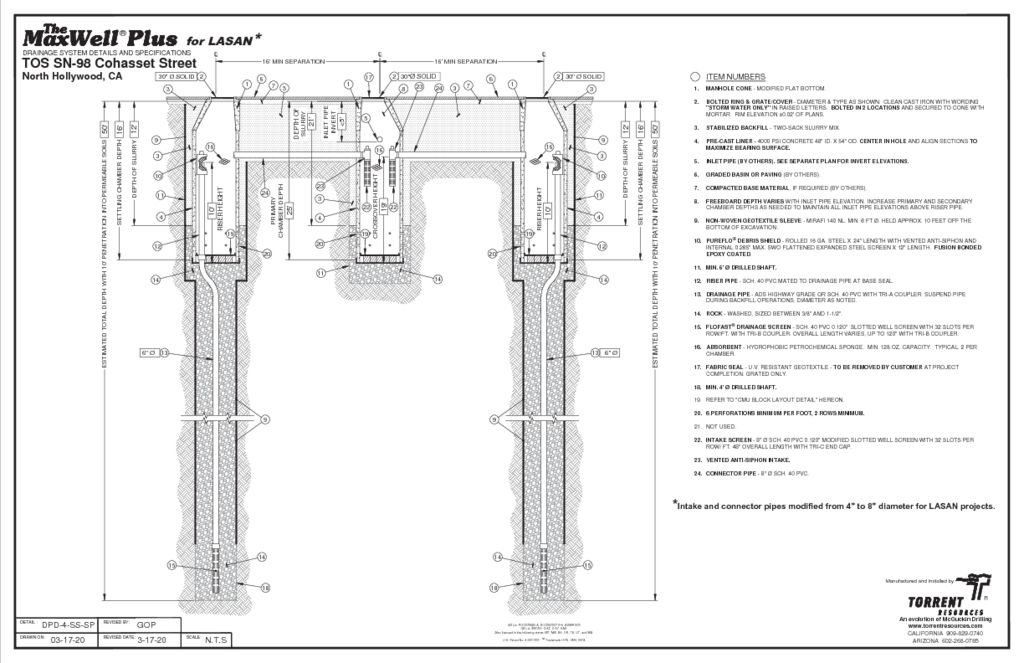
Side view of drywells